
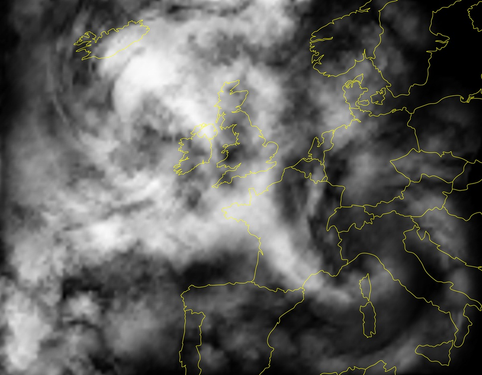
Copernicus , the European Earth Observations Programme, has an impact on a variety of sectors: Climate change monitoring, European security, communications, and maritime security, only to mention a few. The European Commission, on behalf of the European Union, is in charge of the initiative, the European Space Agency (ESA) coordinates data received from satellites whereas the European Environment Agency (EEA) is responsible for sensor information from the ground, the sea and the air.
2014 is an important year for this programme formerly known as Global Monitoring for Environment and Security (GMES), as it entered into its operational phase. The first Sentinel satellite was launched this April, while more will follow in 2015. Already the data from contributing missions provided by ESA, Eumetsat, and other European and international third party mission operators, is highly valuable.
The current Copernicus Programme 2014-2020 is based on Regulation 2014/377 ( OJ L 122 24.04.2014, p. 0044 )
Overviews

Copernicus in brief / Copernicus.eu
Main thematic areas serviced are: land monitoring, marine monitoring, atmosphere monitoring, emergency management, security, and climate change.
Copernicus: The European Earth Observation Programme / European Commission, DG Enterprise and Industry
This website offers access to services, infrastructure, sector applications, Copernicus for regions, a library, and the project database.
Copernicus overview / European Space Agency
The Sentinels are a new family of satellites, developed specifically for the needs of the Copernicus programme.
Copernicus: this is how a satellite “fleet” will study the Planet / ASI Research Italy, 29 July 2014
Analysis
Sentinel Satellites Initiate New Era in Earth Observation / Randy Showstack, Eos, Vol. 95, No. 26, 1 July 2014, pp. 239-240
In addition to explaining the urgency of the operability of the Sentinel satellites, this article remarks on the cooperation with other Earth observation systems like Landsat and focuses on the free and open access to data.
Open Data from Earth Observation: from Big Data to Linked Open Data, through INSPIRE / Massimo Zotti, Claudio La Mantia, Journal of e-Learning and Knowledge Society, Vol. 10, no. 2, 2014, pp. 91-100
While Copernicus opens new perspectives and provides a huge amount of data, this data volume needs to be managed.
Window on Copernicus: discover the Security dimension of Copernicus / Window on Copernicus, Bridges, [2014]
Stakeholders provide insight into the security domain of the Copernicus programme.
Stakeholder views
Copernicus (European Commission’s Earth Observation Programme) / formerly GMES / EOPortal, 2014
The article offers a detailed insight into the background and development of Copernicus, the operations, concept and the infrastructure.
Unique radar instrument for first Copernicus satellite opens new era of environmental observation / Airbus Defence & Space, 31 March 2014
Airbus describes in detail Sentinel-1 and the benefits of environmental observation.
Keeping a watchful eye over earth / Christian Du Brulle, Horizon, 7 October 2013
The EU Research and Innovation Magazine addresses not only the possibilities in disaster relief but also the potential of job creation.
Reinhard Schulte-Braucks, Head, Copernicus, European Commission / Research Media, 16 May 2013
In this interview, Mr. Schulte-Braucks outlines the influence of Copernicus in certain areas and provides a link to the Galileo programme.
EU programmes and projects
Horizon 2020 and Space / European Commission
Horizon 2020 is the financial instrument implementing the Innovation Union, a Europe 2020 flagship initiative aimed at securing Europe’s global competitiveness. Running from 2014 to 2020, with a budget of just over €70 billion, the EU’s new framework programme for research and innovation is part of the drive to stimulate growth and create jobs in Europe.
Galileo / European Commission
The Galileo programme is Europe’s initiative for a state-of-the-art global satellite navigation system, providing a highly accurate, guaranteed global positioning service under civilian control. The fully deployed system will consist of 30 satellites and the associated ground infrastructure. Galileo will be inter-operable with GPS and GLONASS, the two other global satellite navigation systems.
EGNOS / European Geostationary Navigation Overlay Service
The European Geostationary Navigation Overlay Service (EGNOS), Europe’s first venture into satellite navigation, improves the open public service offered by the USA’s Global Positioning System (GPS).


Be the first to write a comment.