

Written by Sidonia Mazur,

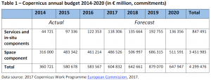
Copernicus is the European Union’s Earth observation and monitoring programme. It has a space component and a ground-based component, and provides users with data services. A user-driven programme under civilian control, it builds on existing national and European capacities, and continues the work of the Global Monitoring for Environment and Security (GMES) programme. Copernicus is based on a partnership between the EU, the European Space Agency (ESA) and the EU Member States. The EU has earmarked almost €4.3 billion for Copernicus in its Multiannual Financial Framework for 2014-2020.
The Copernicus space component incorporates space infrastructure comprising a space element (the satellites) and a ground segment (the infrastructure managing the satellites).
The Copernicus satellites include two mission groups: six families of satellites dedicated to Copernicus, known as the ‘Sentinels’, and approximately 30 contributing missions from national, European and international organisations.
The Copernicus in-situ component consists of environmental measurements collected from ground-based, sea-borne and air-borne monitoring systems, as well as geospatial reference or ancillary data. The in-situ infrastructure is independent from the space infrastructure.
Institutions and agencies at national level own and operate many in-situ data sources; for example, the national air quality monitoring data collected by national meteorological services, which EU Member States are required to report to the European Environment Agency.
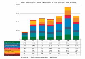
Copernicus provides the following services:
- an atmosphere monitoring service, which provides information on European air quality, and on the chemical composition of the atmosphere on a global scale;
- a marine environment monitoring service, which provides information on the state and dynamics of the physical ocean and marine ecosystems across the globe, and on European regional marine areas;
- a land monitoring service, which provides information on land use and land cover, the cryosphere, climate change and bio-geophysical variables;
- a climate change service, which adds to the EU’s climate change knowledge base, aiming at supporting adaptation and mitigation policies;
- an emergency management service, which provides information for emergency response to different types of disaster, including meteorological hazards, geophysical hazards, deliberate and accidental man-made disasters and other humanitarian disasters, as well as for prevention, preparedness, response and recovery activities;
- a security service, which provides information to help meet the civil security challenges facing the EU, including better crisis prevention, preparedness and response capacities.
The European Commission has evaluated three pre-Copernicus initiatives: the GMES initial operations (GMES GIO) programme for 2011-2013; the 2008-2010 GMES preparatory actions (PAs); and the FP7-funded elements of the GMES space component (GSC) for 2007-2013. The evaluation concluded that the three initiatives provided high levels of ‘European added value’. No single EU country could have created a similar system on its own, as national programmes were much more limited in scope and only fulfilled a limited number of the functions of GMES, and at lower levels of functionality. GMES offered higher levels of assured continuity of service, compared to anything available at national level. The encouraging results of the pre-Copernicus initiatives led to the creation of Copernicus, and the lessons learned included the need to pay more attention to the development of core services and their uptake by users.
While the Commission is in the process of carrying out an ongoing interim evaluation of the Copernicus programme (2016-2017), the results are not yet available.
Read the complete briefing on ‘Copernicus – The EU’s Earth observation and monitoring programme‘ on the Think Tank pages of the European Parliament.


[…] […]
[…] Framework (MMF) for 2014-2020, the EU had earmarked almost €4.3 billion for Copernicus (link). Currently, the MMF for 2021-2028 is being negotiated and unfortunately, the latest proposals and […]